


Districts
Read up and plan your itinerary


More about the districts
Zunheboto

Home to the Sümi Naga tribe, Zunheboto is hailed as ‘The Land of Warriors’. Many of the villages and settlements like Thakiye, Hoshepu, Satoi and Khukishe are believed to be named after Sema warriors of the past. Stories of their martial past still live on in places like Aghunato, which literally means ‘War Mountain.’
Read More
Zunheboto is derived from Zunhebo, the Sümi word for Leucosceptrum canum or Hairy White Wand, a flowering shrub with creamy white flowers bearing unusual brown nectar that attracts birds and insects. The traditional homeland of the Sümis is northeast of the Angami territory. They inhabited the valleys along three large rivers and the mountain ranges and plateaus separating these waters. Zunheboto is a hilly and forested district. The mountainous terrain has moderately steep to very steep slopes dominated by evergreen trees. Sümis have a hereditary chief called akekao (equivalent of king). Their dances, songs and ceremonial war costumes like ashola (Sema loin cloth) are quite colourful. Aphilo kowo, an ancient war dance of the headhunters marks victory over the enemies, and is a staple during festivals. Angushu Kighilhe is another traditional war dance performed by men. The Sümi’s most important festival is Tuluni, a time of feasting and drinking rice wine (incidentally called tuluni), served in a goblet made of plantain leaf. The season of plentiful crops is called Anni and the betrothed and their families exchange baskets of gifts complemented by celebratory meals, folk songs and ballads.
Zunheboto Routes
Zunheboto-Ghosu-K Station : Moderate
Zunheboto to K Station is a lateral traverse across the district starting from Zunheboto driving via Ghukiye to Langki Bridge and Ghosu Bird Sanctuary. Don’t expect too much infrastructure, it’s a DIY place without any signages. Drive past Shena and Saptiqa and stop at the resting shed if you’re low on water supply. There are no shops or facilities on this route and STBC Women Department sometimes keeps a thoughtful self-service crate of mineral water – you can leave money behind in a plastic box. Drive past Ustomi village gate, Zhevishe village marketing shed and Late Hoikhe Hesso memorial and continue on the road to Wokha/Kohima. The road passes through Tsaphimi Reserve Forest, rubber plantations with sheets of latex drying in the sun, and scenic bridges. Just short of the exit point at K Station in Tseminyu, stop by at the roadside memorial of Dhanchu, the brave warrior of Kandi village who fought a tiger.
Satoi Range to Longsa: Moderate
Drive from Akhegwo towards Kiphire and take the diversion to the left from the highway on the tar road crossing a Bailey bridge across the Aphughoki river, towards Khuvuxu (pronounced Khuvukhu). Satoi Range has 11 settlements under its jurisdiction – Khuvuxu, Hokiye, Thakiye, Tsutoho, Satoi village, Satoi town, Itovi, Ikiye, Tsuruhu (good for sighting tragopan), Kheshito and Ghokhuvi. You cross a blue pillar gate with the words Vi Wolo (Safe Journey)/Sasuvi (Welcome) before entering Thakiye. The sharp climb from Kizari in the foothills to Hokiye is the most challenging section in this circuit as the road is very narrow with deep ruts caused by rain channels criss-crossing the track. Wheel placement becomes crucial and in some tight spots, the navigator must get down from the vehicle to guide the driver. Hokiye lies at the crest of the mountain
VK Loop: Easy
Drive from Akhegwo towards Kiphire and take the diversion to the left from the highway on the tar road crossing a Bailey bridge across the Aphughoki river, towards Khuvuxu (pronounced Khuvukhu). Satoi Range has 11 settlements under its jurisdiction – Khuvuxu, Hokiye, Thakiye, Tsutoho, Satoi village, Satoi town, Itovi, Ikiye, Tsuruhu (good for sighting tragopan), Kheshito and Ghokhuvi. You cross a blue pillar gate with the words Vi Wolo (Safe Journey)/Sasuvi (Welcome) before entering Thakiye. The sharp climb from Kizari in the foothills to Hokiye is the most challenging section in this circuit as the road is very narrow with deep ruts caused by rain channels criss-crossing the track. Wheel placement becomes crucial and in some tight spots, the navigator must get down from the vehicle to guide the driver. Hokiye lies at the crest of the mountain
Mokokchung

Mokokchung is the homeland of the Ao Naga tribe, who are believed to have migrated centuries ago from Mongolia through South-East Asia to present day Nagaland. Geographically, the district has six distinct hill ranges almost parallel to each other and aligned roughly north- east/south-west.
Read More
Ongpangkong, the largest mountain range in the district stretches from Longsa in the south to Ungma, Mokokchung, Chungtia, Longkhum, Aliba, Mangmetong, Kinunger and Chuchuyimpang. Asetkong, the smallest range runs centrally east to west between the Melak and Menung rivers, with Mopungchuket, Longpa and Longjang. Langpangkong has NH-61 running on top of the range from Mokochung via Changtongya and Tuli town. Tzürangkong, the lowest range bordering Assam is also known as Naga Foothills. Aos have six major sub-tribes – Jamir, Longkumer, Pongen, Imchen, Walling and Longcherth. Their traditional costume is vibrant. Women sport azük (red and blue necklace with silver bells) and shiret penpang (armlet) while males don the ipha or zübü süjak (cowries apron), chuku mang ive (sash), khampang (ivory armlet), kataba (bracelet), shibu (boar tusk necklace) and thunku (headgear with hornbill feathers) worn only by headhunters. Enemy heads were trophies stored in a chuku pong (basket); a miniature version is used for their dance with a nokleh (dao holder). Across the shoulders is a sakla (woven sash) adorned with horsetail hair. Only the rich and brave warriors were permitted to wear special shawls like Tsungkotepsu or Mangkotepsu.
Mokokchung Routes
Ongpangkong-Asetkong Range: Moderate
Enter the district from the south and drive up the Ongpangkong range from Longsa to Ungma and Mokokchung. Don’t take the usual NH-61 highway via Chuchuyimlang and Changtonya to Tuli. Instead, take the left diversion from Impur Junction for Mopungchuket-Impur past the Yimchalu village gate and the Rural Tourism Lodge of Sungratsu Village. From Mopungchuket, the tar road continues past Sungotenem Park towards the coffee estates of Khar. Backtrack to the neighbouring village of Sungratsu and drive up the central Asetkong range towards Tuli. The 27 km stretch from Impur Junction till Longpong Bridge is a narrow yet decent tar road, after which the real offroad section begins. Continue via Longjang and Kelingmen – there’s an offroad access to Chuchuyimlang (Route 2) from both places though the Longjang access is more treacherous. From Kelingmen, continue via Asangma to the nodal town of Tuli. Take the left from Tuli Market Junction for Molungyimsen and Molukimong to cover the Jangpetkong Range (Route 3) or continue north of Tuli towards the Assam border and turn in from Yajang C, B, A for the Japukong Range (Route 4) via Lirmen, Anokpu and Mangkolemba to Changki Jucntion.
Chuchuyimlang Extn: Moderate
Though Chuchuyimlang lies on the Mokokchung-Changtongya-Tuli NH-61 highway, the offroad access from Longjang or Kelingmen (16 km further up the road) is more interesting and worth the detour. The route from Longjang is tougher with a descent to the Mining river. There’s no bridge and the river crossing is followed by a steep ascent along a narrow, rocky road to Chuchuyimlang. Sometimes this route gets damaged due to landslides, in which case, drive further to Kelingmen and take the right from the T-junction to Chuchuyimlang. This route is moderate in comparison to the first access. Backtrack to Kelingmen if going up to Tuli via Asangma.
Jangpetkong Range: Moderate
From Tuli Market Junction turn left for the Jangpetkong Range, which stretches down to Changki Junction, 62 km away. Cross Luyong Bridge as the road climbs steadily from the plains towards Molungyimsen. The road wends past terraces of paddy fields and great mountain views closer to Molungkimong. Drive past Yimjenkimong towards Waromong and the roadside sacred boulder of Jangjanglong. Cross the diversion for Melak river 12 km to the left; there’s no bridge and it’s 4-5 km from there to Asangma. There are multiple diversions going down to the river like the Dibuia-Melak Link Road. Each place has a story behind its name. Dibuia is named after dibu, a particular kind of small bamboo. Alongma, literally ‘a place of stones’, was the rocky lair and holiday spot for legendary Ao lovers Jina and Itiben. Mongchen is one of the highest points in this route and there are scenic viewpoints overlooking Mangkolemba and Maipang Khar. A small footpath marks the trail the American missionaries took towards Impur Mission Centre. The road condition deteriorates as you drive to Chungliyimsen with its ancient tree and 5 km milestone.
Japukong Range: Moderate
From Tuli Market Junction turn left for the Jangpetkong Range, which stretches down to Changki Junction, 62 km away. Cross Luyong Bridge as the road climbs steadily from the plains towards Molungyimsen. The road wends past terraces of paddy fields and great mountain views closer to Molungkimong. Drive past Yimjenkimong towards Waromong and the roadside sacred boulder of Jangjanglong. Cross the diversion for Melak river 12 km to the left; there’s no bridge and it’s 4-5 km from there to Asangma. There are multiple diversions going down to the river like the Dibuia-Melak Link Road. Each place has a story behind its name. Dibuia is named after dibu, a particular kind of small bamboo. Alongma, literally ‘a place of stones’, was the rocky lair and holiday spot for legendary Ao lovers Jina and Itiben. Mongchen is one of the highest points in this route and there are scenic viewpoints overlooking Mangkolemba and Maipang Khar. A small footpath marks the trail the American missionaries took towards Impur Mission Centre. The road condition deteriorates as you drive to Chungliyimsen with its ancient tree and 5 km milestone.
Kiphire

Surrounded by Tuensang district to the north, Zunheboto district to the west, Phek district to the south and Myanmar to the east, Kiphire is one of the most geomorphologically interesting zones of the state. There are numerous limestone caves in the district at Khongjiri, Mimi and Salumi besides mining locations in Pokphur, which earns the district the epithet ‘Land of Minerals’.
Read More
Criss-crossed by the Zungki, Tizu and Likimro rivers (with a Hydro Project), the name ‘Kiphire’ is derived from the Sangtam dialect meaning ‘Valley surrounded by water’. Unlike other rivers in the state that join the Brahmaputra, Tizu originates in Nagaland and flows into Myanmar where it joins the Chindwin and the Irrawady. After Longleng, Kiphire is the least populous district in Nagaland. It remained untouched by the British colonial administration even after its neighbouring areas were subjugated during the 1920s. The hilly landscape is peppered with beautiful villages like Amikioro, Moya, Mimi and Khong. ‘Apple Village’ Thanamir is the base for the hike to Mount Saramati, Nagaland’s highest peak (3840 m) located in the southeast corner of the district. High ridges, narrow valleys, deep gorges, numerous rivers and streams make Kiphire a veritable paradise for any offroader. The main access is from Akhegwo in neighbouring Phek which leads to a bridge that allows entry into Sangtam territory through an entrance arch that proclaims ‘Welcome to Sangtam Land’. Kiphire has a multi-ethnic indigenous population with three officially recognized tribes – mainly Yimkhiung (earlier Yimchungrü) besides Sangtam and Sümi (earlier Sema), who share close socio- cultural ties with their counterparts in the neighbouring districts of Tuensang and Zunheboto respectively.
Kiphire Routes
Mimi Extn: Easy
The exciting trail to Wawade waterfall takes roughly 1½ hours from Mimi via Betang, a scenic viewpoint. It’s a tar road to Betang, which becomes a mud road after a few kilometers, as you make a descent past Khaha village. The settlement of Khongka can be spotted nestled on a hill with the end of the trail at Hakkomute barely discernible at a lofty elevation in the distance. Park your vehicle by the bridge for the 20-minute hike to the waterfall (it’s safer to pick up a local guide from Betang). After the bridge, there’s a wooden barrier on the road before the ascent to Khongka with several culverts. Continue to Hakkomute and backtrack all the way to Mimi. Directions: Mimi to Hakkomute is 42 km. From Mimi take the road past the 41 Assam Rifles checkpost to Betang, 3 km away. Continue the descent past Khaha village to the bridge 11 km away for Wawade waterfall. Climb 8 km to Khongka, and drive 21 km further to Hakkomute.
Pungro Loop: Moderate
Enter the district at Ngoromi and Longmatra. The confluence of the Tizu and Zungki rivers lies near Longmatra. Take the diversion to the right, off the highway for Pungro and Thanamir for the Pungro Loop. This access is called 02 Rasta named after the GREF company stationed here. It’s a deeply rutted route and a bone-jangling ride on the narrow mud track paved unevenly with stones. From Pungro, drive via scenic villages of Amikioro, Mutingkhong, Moya and Mimi. From Mimi, one can do the Wawade-Hakkomute extension (Route 2), a diversion via Betang to a short, yet tricky hike to Wawade waterfall and continue to the end of the trail past Khongkha to Hakkomute. Drive from Mimi through the remote highlands via Lopfukhong, Khongjiri to Longkhimong and take a diversion to Khong, the end of the road in this nook. There’s a walking trail down to the Vohrtah (pronounced Wu-she-ta) river and Thanamir. The extreme offroad trail (Route 3) from Khong becomes too steep to navigate beyond 1 km. Backtrack to Longkhimong and continue to Salumi, taking a diversion for ‘Apple Village’ Thanamir. Return to Salumi and from Penkim Junction, head to Fakim Wildlife sanctuary, returning to Pungro to complete the loop.
Mimi Extn: Moderate
The exciting trail to Wawade waterfall takes roughly 1½ hours from Mimi via Betang, a scenic viewpoint. It’s a tar road to Betang, which becomes a mud road after a few kilometers, as you make a descent past Khaha village. The settlement of Khongka can be spotted nestled on a hill with the end of the trail at Hakkomute barely discernible at a lofty elevation in the distance. Park your vehicle by the bridge for the 20-minute hike to the waterfall (it’s safer to pick up a local guide from Betang). After the bridge, there’s a wooden barrier on the road before the ascent to Khongka with several culverts. Continue to Hakkomute and backtrack all the way to Mimi.
Kiusum Extn: Moderate
The Kiusum extension, especially the route to the last village Thongsonyu, is a challenging drive for any offroader. The trail starts off easy as you drive north of Kiphire on the highway to Tsar Farm and take a right turn for Phelungre. The trail is moderate as you cross a steel bridge and drive to Latsu, continuing past Sangkhumti to Kiusum. It’s a 2-hr drive from Kiusum via Reicham and Limtsang to Pokhpur. Continue driving another hour via Tikhingkhiu to reach Thongsonyu, the end of the trail. This is the most treacherous offroading stretch and one has no choice but backtrack the same way to Kiusum.
At Kiusum, one has three options – 1) Return the way you came westwards to Phelungre and Tsar Farm back to Kiphire. 2) Drive south via Longtsunger towards Pungro, Penkim or Thanamir. 3) Head north and exit Kiphire district to reach Pang, 14.7 km (4-5 hours) in Noklak district (See Page __) via Chikiponger and Vitsuvong. The route takes you past cornfields and a rocky river crossing. The river is 20-30 ft wide and the water level is almost mid tyre height (Be aware, water levels increase considerably in the rains). Drive through a narrow gorge before tackling the difficult ascent to Pang in Noklak district regarded as the home of the Khiamnungan tribe.
West of the Highway: Moderate
Turn off the highway after Longmatra village for Honito along a decent patch. From here it is a challenging drive to Nitoi, along a hilly stretch with frequent furrows and ditches. Though the route is moderate, it could get rather tricky in the rains. From Nitoi, continue to Sitimi a kilometer ahead, from where it is a smooth black top to Shishimi, except for a few places where bridges are being constructed. From Shishimi backtrack to Sitimi that has a GREF Camp. Instead of taking the good highway from Sitimi to Seyochung, drive on a black top via Kiyezhe and Natsami to Langzanger. From Langzanger the road deteriorates considerably and becomes difficult after the right deviation for Tsunger. Driving further, the level changes to extreme as you pass through dense forest with an obstacle course of marshy path, water and grass onward to Seyochung. Seyochung to Lukhami is a black top and a well used path. From Lukhami to Kisetong the route is good, as you continue to Changchor.
West of the Highway: Difficult
Turn off the highway after Longmatra village for Honito along a decent patch. From here it is a challenging drive to Nitoi, along a hilly stretch with frequent furrows and ditches. Though the route is moderate, it could get rather tricky in the rains. From Nitoi, continue to Sitimi a kilometer ahead, from where it is a smooth black top to Shishimi, except for a few places where bridges are being constructed. From Shishimi backtrack to Sitimi that has a GREF Camp. Instead of taking the good highway from Sitimi to Seyochung, drive on a black top via Kiyezhe and Natsami to Langzanger. From Langzanger the road deteriorates considerably and becomes difficult after the right deviation for Tsunger. Driving further, the level changes to extreme as you pass through dense forest with an obstacle course of marshy path, water and grass onward to Seyochung. Seyochung to Lukhami is a black top and a well used path. From Lukhami to Kisetong the route is good, as you continue to Changchor.
Most travellers drive straight from Changchor to Amahator but the lower loop is quite an exciting challenge. It’s a descent via the small new settlement of Bilongkyu down in the valley to Keor and uphill to Amahator, the worst stretch. Locals don’t take this loop which is an unused, narrow, grassy path with a sharp drop to the valley. This is easily be regarded as Grade 3 offroad. The route from Amahator to Risethsi New is fine, but turns difficult from Risethsi to Pungrungru due to on-going road cutting work and increased chances of rockfall, despite the road being wide. From Pungrungru drive 30 min on the Rurur route to a massive tree of nearly 40 ft diameter and continue further to Tsuthu. Check out the local textile weaving in the village and time permitting, hike to the ancestor stones in the forest. The road to Tsar Farm is muddy and difficult and can dramatically become extreme with one rain. Drive towards Kiphire and 6-7 km north of town, stop at a nice picnic spot where one can have a bath in the river and clean the vehicles.
Khong Extn: Extreme
Turn in from Longkhimong via Tsurevong towards Khong. In May-June, one can pluck the susel-zee-ken berries lining the roadside. The thorny shrub – zee means ‘thorn’ and ken is ‘fruit’ in Yimkhiung – yields wild orange berries whose fresh burst of sweetness is perfect after a long drive. It’s great survival food in the outdoors – watch out for thorns while plucking and be mindful of the road edge. Beyond the Baptist Church, the road cutting has been abandoned after a short distance. However there’s a steep walking trail nearby that leads down to the Vorhrta river. The track descends through a dense and winding bamboo forest. This route serves as an extreme offroad drive that requires technical skill. Do not attempt this route alone. The path suddenly trails off down a steep boulder ridden slope that leads to the river, accessible only on foot. Turn back and do not attempt driving down to the river. The 4x4 return drive to Khong is equally challenging and demands winching one’s way up due to the gradient of the terrain and slippery bamboo. Locals take around 1½ hrs to trek from Khong to Thanamir by this route.
Phek
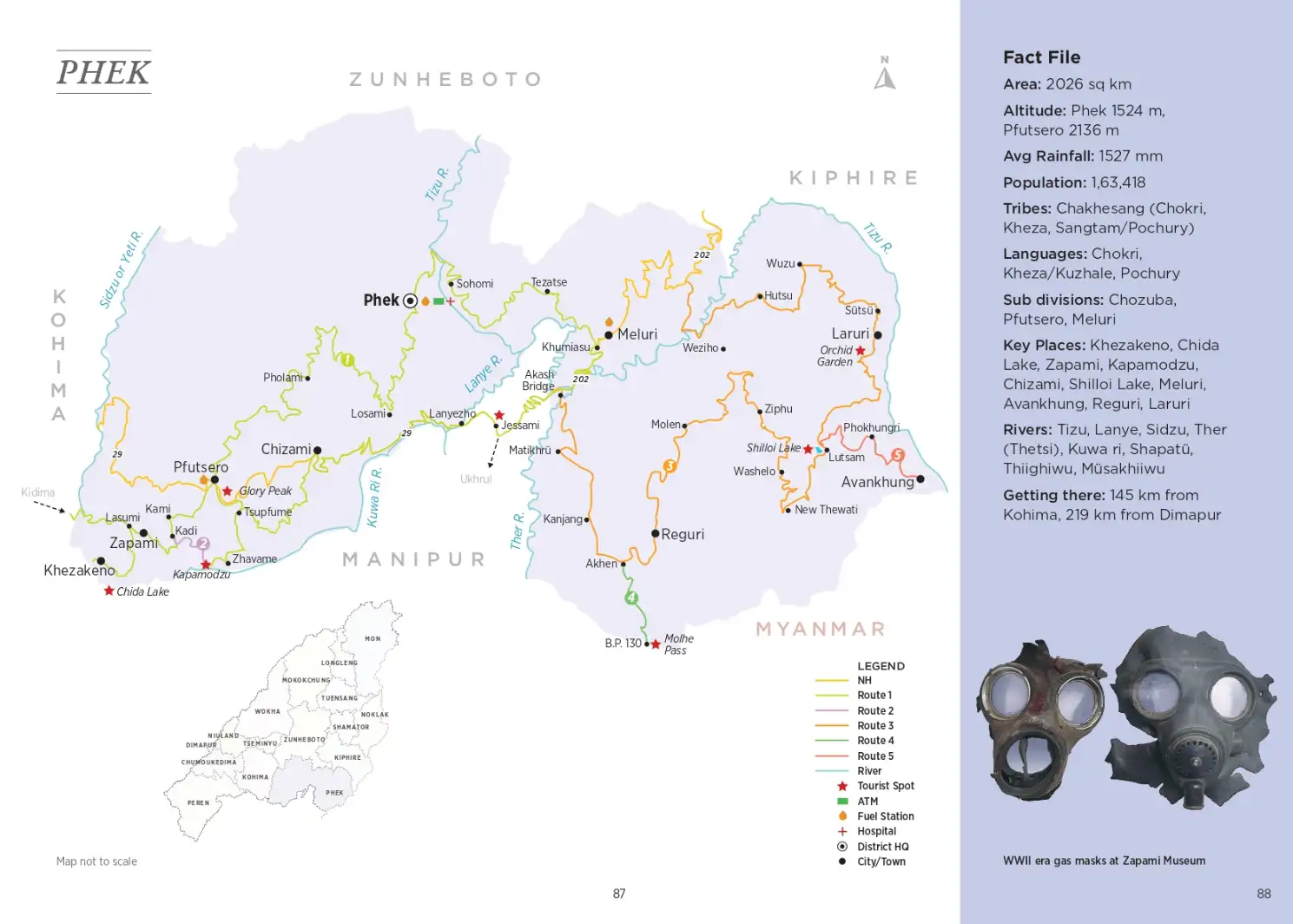
Derived from the word Phekrekedze meaning ‘watchtower’, Phek is a land of lofty heights and gushing rivers. One of the bloodiest battles between the Nagas and the British took place in 1851 at Kikruma. During British rule, the people of this region to the east of Kohima were called Eastern Angami.
Read More
Ongpangkong, the largest mountain range in the district stretches from Longsa in the south to Ungma, Mokokchung, Chungtia, Longkhum, Aliba, Mangmetong, Kinunger and Chuchuyimpang. Asetkong, the smallest range runs centrally east to west between the Melak and Menung rivers, with Mopungchuket, Longpa and Longjang. Langpangkong has NH-61 running on top of the range from Mokochung via Changtongya and Tuli town. Tzürangkong, the lowest range bordering Assam is also known as Naga Foothills. Aos have six major sub-tribes – Jamir, Longkumer, Pongen, Imchen, Walling and Longcherth. Their traditional costume is vibrant. Women sport azük (red and blue necklace with silver bells) and shiret penpang (armlet) while males don the ipha or zübü süjak (cowries apron), chuku mang ive (sash), khampang (ivory armlet), kataba (bracelet), shibu (boar tusk necklace) and thunku (headgear with hornbill feathers) worn only by headhunters. Enemy heads were trophies stored in a chuku pong (basket); a miniature version is used for their dance with a nokleh (dao holder). Across the shoulders is a sakla (woven sash) adorned with horsetail hair. Only the rich and brave warriors were permitted to wear special shawls like Tsungkotepsu or Mangkotepsu.
Phek Routes
Shilloi Extn: Easy
The jaunt from Shilloi Lake via Phokungri to Avakhung makes a perfect day outing and a 24 km run one way. The route is bumpy in patches along a rocky road going past cliffs but is manageable for beginners. At Avakhung fork, the right climbs up to the Assam Rifles post, helipad and the ITC (International Trade Centre), while the left descends to the border checkpost and village.
Kheza Loop: Easy
An exploration of the left half of the district, this offroad route takes you through Chakhesang territory, specifically the Kheza or Kuzhale area to the south. Starting from Kohima, drive via Kidima on this linear route running south of the Kikruma-Chizami highway. Drive via the historic villages of Khezakeno, Zapami and Kami, base for an extreme 4km offroad short cut to Kapamodzu (See Route 2). Most people take the usual longer route via Pfutsero, Tsupfume, Razieba (Razeba) to Zhavame, the base for Kapamodzu. Backtrack to Zhavame, Zalome and Razeba and drive past Nagaland’s Stonehenge Tsupfume towards Tetsume and rejoin NH-29 or the Kohima-Jessami Highway at Chizami. From Chizami, drive past the historic Sumi village and take a scenic back route to Losami Junction, cross Lanye or Lanezho Bridge, passing through a small section of Manipur to Jessami. Head to Meluri and take the deviation near the petrol bunk towards Tezatse and drive to district headquarters Phek, continuing via Khomi, Sakraba and Porba back to Pfutsero to complete the loop.
Kheza Loop: Moderate
An exploration of the left half of the district, this offroad route takes you through Chakhesang territory, specifically the Kheza or Kuzhale area to the south. Starting from Kohima, drive via Kidima on this linear route running south of the Kikruma-Chizami highway. Drive via the historic villages of Khezakeno, Zapami and Kami, base for an extreme 4km offroad short cut to Kapamodzu (See Route 2). Most people take the usual longer route via Pfutsero, Tsupfume, Razieba (Razeba) to Zhavame, the base for Kapamodzu. Backtrack to Zhavame, Zalome and Razeba and drive past Nagaland’s Stonehenge Tsupfume towards Tetsume and rejoin NH-29 or the Kohima-Jessami Highway at Chizami. From Chizami, drive past the historic Sumi village and take a scenic back route to Losami Junction, cross Lanye or Lanezho Bridge, passing through a small section of Manipur to Jessami. Head to Meluri and take the deviation near the petrol bunk towards Tezatse and drive to district headquarters Phek, continuing via Khomi, Sakraba and Porba back to Pfutsero to complete the loop.
Pochury Loop: Moderate
The Pochury territory is divided into five ranges or areas – Kamalaya, Meluri, Apoksah (Akhegwo), Phojesa and Phokungri. While driving in from Jessami, just before Akash Bridge over the Tizu river, you turn right and begin the ascent of the first range Kamalaya. It is a loose acronym for the six villages in the western part – Kanjang, Akhen, Matikhru, Akhen, Mollen and Reguri. Crossing Matikhru and Kanjang, you reach Akhen, the base for an offroad extension to Molhe Pass near Border Pillar 130 (See Route 4). From Reguri, make a scenic descent through a pine forest to the fields by the river and drive via Ziphu to Mollen. The drive takes you through forested tracts till you reach a fork in the road - the left leads to Phor and the right to Lake Shilloi. You have to cross a small river called Laiyakti, literally ‘one whose water never gets less’. Drive past Washelo and Thewati to reach Lake Shilloi. From Shilloi, you can do an extension via Pokhungri to the border town of Avangkhu (Route 5). Continue from Shilloi Lake via Laruri to Akhegwo and Meluri.
Akhen Extn: Difficult
From Akhen there’s an offroad ascent to Molhe Pass near Border Pillar 130 at the Myanmar border. The first part of the climb from Akhen towards BP 130 is beautiful with undulating hills, tracts of pine and wild flowers, including a rare tree bearing white rhododendron flowers! Being a Shaktiman route in active use for timber logging, there aren’t any major obstacles. But as you enter the forest, the track deteriorates into slush. The earth is clayey and some sections are challenging. One needs steady acceleration on second gear, otherwise the vehicle won’t climb, losing steam mid way. On top, the track opens out into a wide plateau at the summit. One has to backtrack on the obstacle course of forest, slush and gravel with a slow and careful descent along a cliff’s edge back to Akhen.
Kami-Kapamodzu: Extreme
The regular access to Kapamodzu is via Zhavame but there’s an extreme off-road route from Kami to Kapamodzu. A Polaris route had been created few years ago for Pfutsero Experience but this access is tricky as the forest path is barely wide enough for four-wheelers in some sections. Proper wheel placement is crucial, down to the last inch. The foliage is dense and overgrown with bamboo thickets, evergreen native trees and fallen tree trunks and the route is sunless because of the thick canopy. Some ascents seem deceptively mild but are full of complexities due to ground conditions. Keeping momentum on wet soggy earth, slippery undergrowth, hidden rocks and acute slopes flanking the narrow muddy forest track offer little traction on caked tyres so the tendency to skid or go into wheel spin remains high. This route demands technical driving skills and quick thinking and response. Be prepared to winch, push, tug and claw your way up to Kapamodzu; a battle fought inch by inch. For offroaders, it’s insane 4x4 action. Don’t attempt it alone.
Wokha

Located in the mid-west of Nagaland, Wokha district is home to the Lothas (also called Kyong Nagas), indigenous inhabitants who supposedly migrated here from Khezhakeno village in Phek district. It’s believed they possessed a magic stone called Phitsson Long (phi means ‘spread’, tsson is ‘to increase’ and long is ‘stone’).
Read More
Legend has it, if a head load of paddy was spread on the stone and sundried in the morning, it magically doubled by afternoon. An argument on who had rights over it triggered the first wave of migration. When the Lothas migrated to the present area they built the first village at Tiyilongchum on the southern ridge of Mt Tiyi, from where they spread out to the whole district.
Mount Tiyi (6600 ft), the highest peak in the district is a short hike from Wokha village. Associated with supernatural legends and folklore, it is believed to be the abode of departed souls. The name ‘Wokha’ is derived from ‘Wo’, Lotha for ‘number of people’ and ‘Kha’ meaning ‘counting.’ Thus, Wokha literally means ‘head count’ or ‘census.’ Most hilltop villages of the Lothas are built aroundancient stone monoliths (Longsu). During the British colonial administration, Wokha was designated the District Headquarter of Naga Hills under Assam in 1876 until it was shifted to Kohima when it became a sub-division, before being carved into a separate district in 1973.
Wokha Routes
Doyang Drive: Easy
Driving in from Kohima, enter Wokha district from the south via Tseminyu and K Station. It’s a regular highway to district headquarters, Wokha. Continue north of town to Zero Point junction and take the diversion to the left towards Doyang. After 1 km, near Wokha Baptist Church Gate at Vankhosung, take the diversion to the left for Humtsoe. Drive 3 km on this bumpy road to get a glimpse of Sosurochu waterfall in the far distance on the left, just below Wokha town. It may not merit a great waterfall view but it is good oroad to Humtsoe. Backtrack to the highway and drive on a smooth winding tarmac towards Doyang. Take the deviation to the right through Yikhum village gate towards Englan and Riphyim, which has a tourist lodge. The road continues to Changsu New, the end of the trail from where one can see the Doyang river below. Backtrack to Englan and drive to Thillong, a cluster of teashops near Lotha Bridge. Turn in before the bridge to Doyang South Wing to the viewpoint, reception and multi-purpose hall. From Doyang, take the North Wing route via Asha, Pangti and Okotso to exit Wokha and drive to Longkhum in Mokokchung district. Or, backtrack the way you came to Zero Point and take the highway via New Wokha to Doyang Bridge. The widening of the 2-lane NH-61 highway has been done from Tsungiki to Izheto, 24 km away on the Mokokchung route. At Doyang Bridge, take the deviation for Philimi and Roto in Zunheboto district.
Okotso-Pyotchu Traverse: Moderate
This lateral traverse across Wokha from Okotso in the east to Pyotchu/Ralan in the southwest is an exciting oroad route. Enter Wokha district from the east via Longkhum in Mokokchung district, driving in via Okotso to Pangti, the village where thousands of Amur falcons roost annually in Oct-Nov. The forest has teak, bamboo and banana and the mud road is pretty bad. Continue via Asha to Doyang Hydro Project North Bank and drive to Sanis on the highway. The route to Pyotchu is along a ridge that follows the course of the Diyung or Tapu river to the left with the plains of Assam to the right. This is a coal-mining area, and after Tsopo, all the descents to the right from Chudi, Longtsung and Lotsu, lead to coal mines. The road is patchy, alternating between tarred and rough, and gets slushy in the rains. Buses ply only till Longtsung. After Pyotchu, the Diyung river takes an upward curve and one has to cross the river to reach Ralan.
Kohima
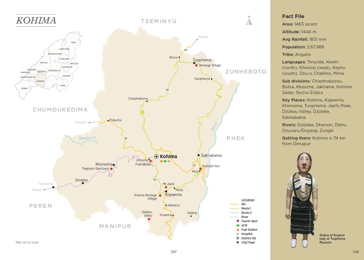
Read More
In 1945, representatives of the three sub tribes Chokri, Kheza and Sangtam (Pochury) met at Phek village to create a new tribal identity and nomenclature. Three syllables were borrowed from each tribe - ‘cha’ ‘khe’ and ‘sang’. The committee mulled over three options – Sangkhecha, Khechasang and Chakhesang, eventually choosing the third option as it had the names arranged in alphabetical order. Agriculture is the main occupation with widespread jhum and terrace rice cultivation that turns the landscape into a vision of green in the monsoon which sets in by end-May and before drying into shades of brown in autumn. While Chakesang is made up of three tribes Chokri, Kezha and Sangtam, Pochury is a composite tribe formed by three Naga communities – Kupo, Kuchu and Khuri who were based in their native villages Sapo, Kuchu and Kwiry respectively. According to legend, these villages had frequent skirmishes until their elders negotiated peace and finally united into a single tribe called Po-chu-ry, derived from the name of the tribes/villages. Having given up their warring ways, many songs of the Pochury are about revelry, merriment and drinking zutho (rice beer). There are cultural troupes at Reguri and Phokhungri, lead singer Longi Liiziiri from Phokhungri has a YouTube channel called Longi Vlogs on his music and village life. Kiijukhwi (Leaping Song) is about a nostalgic lady who sings to her lover working in the field to meet her and to place a flower at the junction so she knows it’s him.
Home to the brave Angamis, Kohima witnessed fierce battles with the British who sought a foothold in the region. The name Kohima is a British corruption of the Angami word ‘Kewhima’, which in the Angami language Tenyidie means ‘The land where the Kewhi flower grows’, a wild flowering plant that grew profusely in these mountains.
Read More
Originally just one of three districts in Nagaland, the once large Kohima was divided several times to carve out newer districts – Phek in 1973 to the east, Dimapur in 1998 to the west, Peren in 2003 to the southwest and Tseminyu in 2021 to the north. After Dimapur, Kohima is the most populous district in the state. Spectacular natural sites like Dzukou Valley, Mount Japfu, Dzuleke and Khonoma attract several visitors each year, especially during the Hornbill Festival at Kisama heritage village. Being centrally located, Kohima is ideal for longer forays across Nagaland.
During World War II, Kohima played a crucial role and the Kohima War Memorial is testimony to it. Set on the former tennis court of the old DC’s Bungalow on Garrison Hill, it witnessed one of the fiercest battles of World War II. The hand-to-hand combat in the 1944 Battle of Kohima was pivotal in stalling Japan’s Burma campaign and its entry into India. The significance of Kohima in world history can be gauged from the title it earned after the war – ‘Stanlingrad of the East’. The World War trail continues to Kigwema where the Japanese Army encamped, and Sakhabama (formerly Chakhabama) where the hut in which Netaji Subhash Chandra Bose’s stayed still stands.
Kohima Routes
World War II Trail: Easy
The drive from Kohima to Peren through the Western Angami region is a historic route. In 1885, a bridle path was built from Kohima via Khonoma, Dzuleke, Peletkie, Benreu and Pedi to the remote outpost of Tening in present-day Peren district. This was one of the earliest roads built in the region. The highway is currently being widened, so watch out for dumpers and road construction equipment.
Western Angami Trail: Easy
An exploration of the left half of the district, this offroad route takes you through Chakhesang territory, specifically the Kheza or Kuzhale area to the south. Starting from Kohima, drive via Kidima on this linear route running south of the Kikruma-Chizami highway. Drive via the historic villages of Khezakeno, Zapami and Kami, base for an extreme 4km offroad short cut to Kapamodzu (See Route 2). Most people take the usual longer route via Pfutsero, Tsupfume, Razieba (Razeba) to Zhavame, the base for Kapamodzu. Backtrack to Zhavame, Zalome and Razeba and drive past Nagaland’s Stonehenge Tsupfume towards Tetsume and rejoin NH-29 or the Kohima-Jessami Highway at Chizami. From Chizami, drive past the historic Sumi village and take a scenic back route to Losami Junction, cross Lanye or Lanezho Bridge, passing through a small section of Manipur to Jessami. Head to Meluri and take the deviation near the petrol bunk towards Tezatse and drive to district headquarters Phek, continuing via Khomi, Sakraba and Porba back to Pfutsero to complete the loop.
Peren
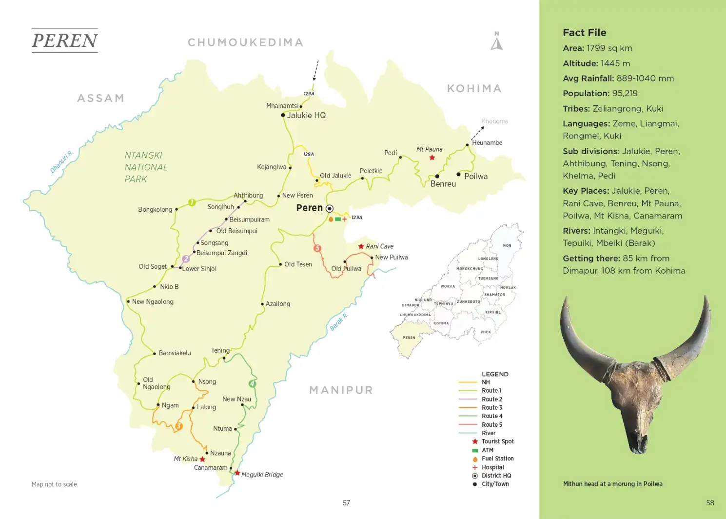
Nagaland’s recorded history begins in Peren with the first Anglo-Naga conflict at Poilwa. In 1832, the British sought a direct link between Assam and Manipur through Naga territories, which resulted in a head-on confrontation with fierce headhunters. They encountered the Zeliang and Kuki tribes and faced the Kuki rebellion in 1917-18.
Read More
Later, during the Kuki Naga conflict, several villages were abandoned and some resettled. For a region that witnessed so much strife in the past, Peren is a peaceful haven today. Being a border district, it has a mixed population as people from different places like neighbouring Tamenglong (Manipur) and Haflong (Assam) besides Tening in Nagaland, have settled here. Peren is home to primarily the Zeliang and Kuki tribes. One of the dances of the Zeliang tribe is Herielim (Hornbill Dance), performed by males and females in poupainia (traditional costume) replete with peurie (male head dress) and hetungeu (female head dress). The melodious voices are set to the accompaniment of the nsambung (drum), ntui (cymbals) and ntiam (flute). Kuki ladies perform the Molkanglam (Stick Dance) and Suhtalam (Bamboo dance) while the Khulkonglam (War dance) is a mixed dance, and Galmano (Hunting dance) performed exclusively by boys.
Peren Routes
Peren Extn: Easy
From the district headquarters Peren, drive via Mpai Junction to Puilwa (not be confused with Poilwa near Heunambe). Located on the Manipur border, Rani cave at Puilwa was one of the hiding places of freedom fighter Rani Gaidinliu and AZ Phizo. Backtrack the way you came to Peren or continue on the road to Manipur and drive via Tamphung and Ndunglwa back to Peren.
Peren Loop: Moderate
Mhainamtsi is the gateway to Peren district and this radial loop is the main arterial route with off-road extensions from nodal points like Ahthibung, Ngam, Tening and Peren. Jalukie to Ahthibung is supposed to be a black top made years ago but the surface disintegrates as you drive further away from town.
From Dimapur, turn right at Chumukedima and drive via Vidima, Shitovi Junction to Mhaikam – there are a few homestays in the area. Pimla has a few tea shops and vegetable vendors. Cross Mhainamtsi and turn right at the T-junction towards Jalukie. The DC’s office is at New Peren HQ Complex near Kejanglwa village, 51 km from Dimapur, with an offroad short cut to Ahthibung. Drive 3km to the Baptist Church in New Peren, turn right to Old Chalkot 7km away and turn left on the main road to Ahthibung, 3km away. One can do an off road route from Ahthibung to Lower Sinjol via Old Beisumpui, Songsang and Beisumpui Zangdi
Tening - Canamaran Extn: Moderate
From Tening, it’s a dusty drive on a kachcha (mud) road to New Nzau, a village named after its founder. The view of Kchalwang mountain forms the backdrop. It has a small store where you can pick up supplies. Further ahead at Ntu/Ntuma, there’s Sangsang’s Tea Stall, the only refreshment option en route. Passing through bamboo thickets, the trail descends via the last settlement Canamaram to the scenic Meguiki river with a Bailey bridge. This is Nagaland’s southernmost point. The confluence of the Meguiki and Barak river is located across the bridge beyond the Nagaland-Manipur border at Kedang.
Ahthibung Extn: Difficult
From Ahthibung, junk the highway to Bongkolong and Gopibung (Zero Point) and take the offroad via the ancient Kuki village of Songlhuh to Old Beisumpui, which eventually connects via Songsang, Beisumpui Zangdi to Lower Sinjol. This stretch promises perhaps the slowest pace of travel you can expect in Peren district and three days of intense offroading action.
Ngam Extn: Difficult
The drive from Ngam to Lalong is through thick forest and lots of slush. The path is taken by timber trucks so expect huge clayey furrows all along. Lalong was originally called Kleubanglo or ‘Pine Tree Village’ and has 97 homes and a pretty Baptist Church. This is known as the Kicha area, after the mountain that dominates the landscape.
Noklak
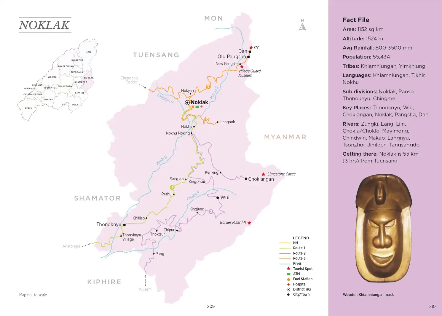
A remote frontier district on the India-Myanmar border, Noklak is a mountainous region in the easternmost part of the state dominated by forests, hills, streams and waterfalls. The district’s entire eastern boundary stretches for nearly 92 km between Boundary Pillars BP 139 and BP 146 and forms the Indo-Myanmar Border.
Read More
The historic caves, boulders and natural sites, each with its own mythology and folklore, adds colour to the explorations.
Home to the Khiamnuingan tribe, Noklak is known for its tribal tours and colourful festivities all year round. One can witness locals fashion an astonishing array of handicrafts from locally sourced materials – blacksmith, pottery and dao making at Wui, cups, spoons and kitchen implements fashioned out of bamboo at Sanglao or women at Choklangan village weaving Elon-yu/Eloiniu fabric out of stinging nettle thread. People often get training from Handicraft Resource Centre, Dimapur, and the district headquarters Noklak town hosts several textile and handicraft exhibitions.
Being a relatively new district carved out of Tuensang district in 2021, Noklak is still low in infrastructure but offers exceptional opportunities to the intrepid traveller. The Lam-den mini hydro project is the only industrial infrastructure project within the district. Located 16 km from Noklak town, the mini hydro project has a power generation capacity of 1MW. The Lang river meanders along lush paddy fields of Pangsha village while the Chokla river tumbles down from the limestone caves of Choklangan.
Noklak Routes
C-Saddle-Pangsha-Dan: Moderate
Drive in from Tuensang via Chendang Saddle and turn o towards Chingmei for the drive to Noklak, the district headquarters. Being a new district, there is a lot of fresh road cutting en route, so be aware of sudden landslides. Bear in mind that it becomes a lot trickier in the rains. Phone network gets patchy towards the interiors. From Noklak one can take a diversion to Langnok and backtrack to Noklak. The route to Pangsha and Dan follows the Makao river and is quite challenging with plenty of slippery red mud and slush.
Anatongre-Noklak: Moderate
Enter Noklak district from Kiphire driving up the highway to Anatongre. Take the diversion to the right for Thonoknyu and descend to the Zungki river before making the slow ascent to sub division headquarters Thononkyu. The road traverses the area between the Zungki and Chokla rivers. The path is difficult and narrow in sections with steep drops on one side, so correct wheel placement is critical. Drive via Chilliso and Peshu to Sanglao and up to Nokhu. From Nokhu descend to the Makao river and climb up to district headquarters Noklak.
Pang - Choklangan Loop: Moderate
Enter from Kiusum in Kiphire district and come into Noklak district through Pang in the south. From Pang, cross the Chokla river, and climb up to Thonoknyu, the nearest nodal town to refuel if low on gas or provisions. Else, continue on a good road via Thoktsur to Chipur. After Chipur, the route deteriorates, making it a dicult road to Kingjung, a fairly large town. Kingjung to Wui is the toughest and worst section, with a slippery narrow path passing through hilly terrain. There are ditches caused by rain channels and the red mud is very slippery, so if you lose momentum, the vehicle tends to slide back. Proper wheel placement is required. If it rains, the oroading level becomes extreme. Wui is known for its dao making, blacksmiths and pottery. From Wui, there’s a shortcut via a dilapidated wooden bridge over the Chokla river, though the longer route via the steel bridge is more reliable. The road is ok till the bifurcation, and the left route to Kingphu is usually not passable, so take the upper route. It’s slushy, red mud and the route from Kingphu to Sanglao is wide but still a bad stretch.
Choklangan Extn: Moderate
Take a hike to Choklangan Caves.
Longleng

Home to the brave Angamis, Kohima witnessed fierce battles with the British who sought a foothold in the region. The name Kohima is a British corruption of the Angami word ‘Kewhima’, which in the Angami language Tenyidie means ‘The land where the Kewhi flower grows’, a wild flowering plant that grew profusely in these mountains.
Read More
When the British established their first post in the Naga Hills at Samaguting (Chumukedima) in 1866, Wokha became the district headquarter in 1876, until it was shifted to Kohima in 1878 and remained so thereafter. When the state was formed in 1963, Kohima was a natural choice as Nagaland’s capital and became the first seat of modern administration. The old Angami settlement of Bara Basti that morphed into Kohima town happens to be the second largest village in Asia. Its erstwhile seven lakes and gates may not have survived, but the impressive entrance to T Khel still stands. Kohima played a crucial role during World War II and the Kohima War Memorial is testimony to it. Set on the former tennis court of the old DC’s Bungalow on Garrison Hill, it witnessed one of the fiercest battles of World War II. The hand-to-hand combat in the 1944 Battle of Kohima was pivotal in stalling Japan’s Burma campaign and its foray into India. So crucial was its role, it earned the title “Stanlingrad of the East”. Follow the World War trail to Kigwema, Chakhabama and beyond and visit spectacular natural sites like Dzukou Valley, Mount Japfu and Dzuleke.
Longleng Routes
Tamlu-Longleng: Easy
Enter Longleng district from Wakching in neighbouring Mon district and take the highway to Tamlu, a 3-hour drive on a patchy surface that is unpaved in sections. Tamlu to Kangching is a black top but as you descend to the Dikhu river and ascend to Amosen via Tangha, which has a small lake, the path is riddled with nallas caused by rain channels. The furrows run about 2 feet deep so watch out for proper wheel placement. The road gets better as you drive from Amosen via Yotan S Compound and Yongshei to Yongnyah that takes over an hour. It’s a very beautiful drive up. This is a good hard patch of road so you reach Nian in under an hour and it takes 1½ hours to Longleng via Yongam and Bhumnyu, which has caves dating back to the era of Ahom Rajas.
Longleng-Sakshi: Easy
The drive south of Longleng towards Tuensang takes you to one of the prettiest and most picturesque villages in the district – Sakshi. There’s road construction on this route so watch out for heavy vehicles and landslides in the rains. Drive via Pongo which has the charming Shamnyu Lake, and Yongphang, known for its traditional pottery. Witness how local artisans crafted clay pots from a lump of clay. From Sakshi, drive via Auching to exit Longleng district and join the highway near Tobu in Mon district or connect to Sangchen Compound to embark on the Tuensang oroad trail. Alternately, you could backtrack from Sakshi to Longleng and take the highway to Changtongya via Orangkong, Alayung and Sanglu.
Tseminyu
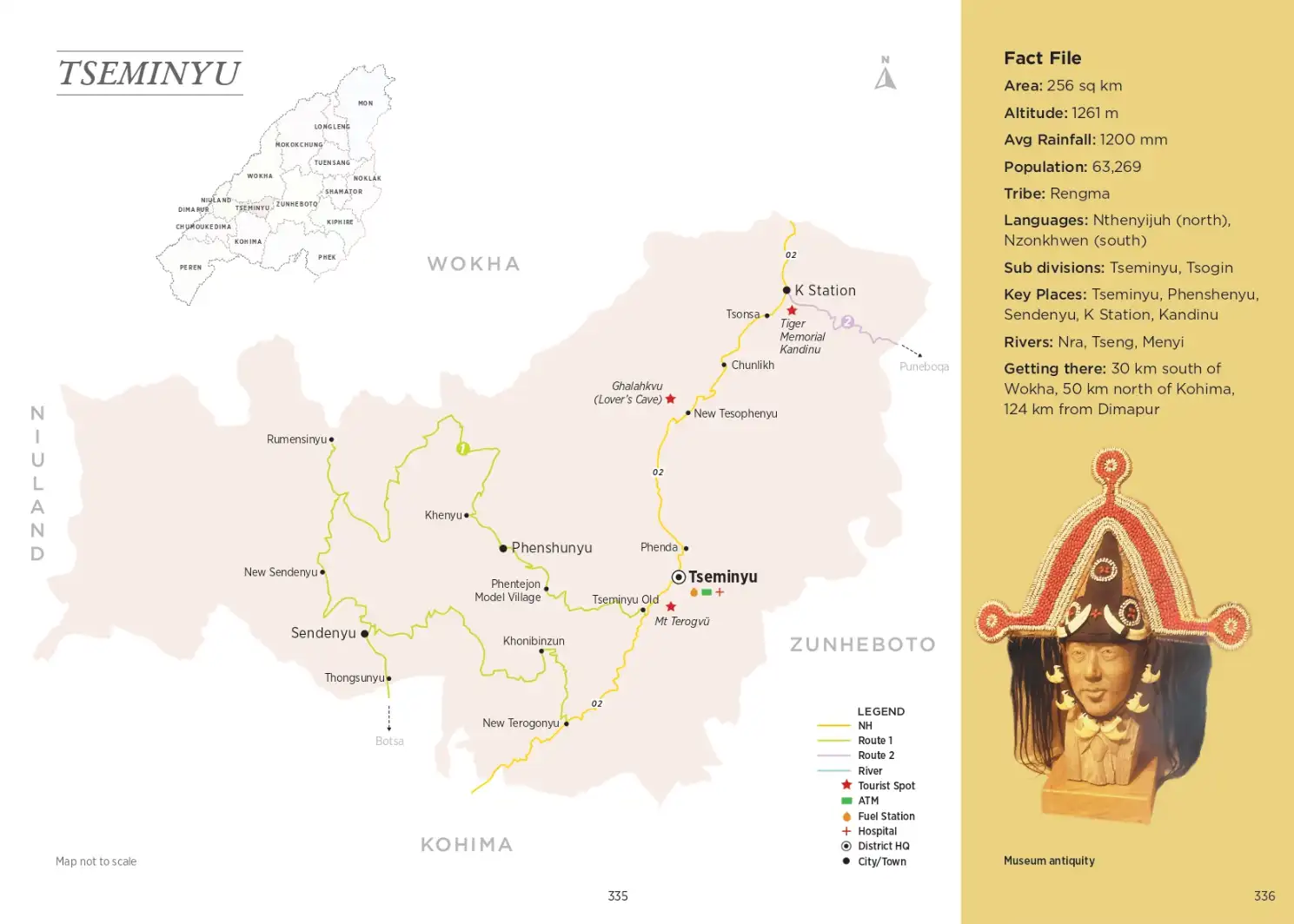
Once a sub-division under Kohima, Tseminyu was carved out as Nagaland’s 13th district in December 2021. Home to the Rengma tribe, the villages of Tseminyu were among the first to engage with the British. It was their early contact with the British that made the region of Tseminyu known to outsiders.
Read More
The Rengmas referred to the British as Kechonyu (white men), after they set up headquarters at Kohima in 1866. As early as 1914, Kamvurhi and Lokhing of Tseminyu village served as Technical Drawing Master and vaccinator for the British at Kohima. They were not only the first Rengmas, but also amongst the first Nagas to serve the British administrators. In Rengma area, Kekhapfu, Nrilo and Rusilo of Tseminyu village were the first dobashis (translators). Zeluzu was among the first few Rengmas to embrace Christianity and the first Rengma missionary.
Tseminyu Routes
Tseminyu-Botsa Loop: Easy
This deviation o NH-2 from Old Tseminyu goes via Phentejon Model Village to the historic village of Phenshunyu and Khenyu before meandering along to Rumensinyu. Drive south to New Sendenyu and Thongsunyu. From here, one can drive via Khonibinzun to Terogunyu on NH-2 or drive to Botsa to rejoin the highway a little south of Terogunyu. Directions: From Old Tseminyu, drive 5.2 km to Phentejon Model Village and drive 5 km to Khenyu via Phenshenyu. Head 18 km to Rumensinyu, 6.7 km to New Sendenyu, 5.8 km to Thongsunyu and 8.4 km to Botsa.
Mon

The northernmost district of Nagaland, Mon shares its eastern border with the Indo-Myanmar boundary, Assam to the north and Tirap district of Arunachal Pradesh to its northeast. Mon is the proud land of the Konyaks, the largest and fiercest of all Naga tribes.
Read More
They follow the Angh (hereditary chief) system and there are seven Chief Anghs within Mon district – Mon, Longwa, Shangnyu, Chui, Shengha Chingnyu, Jaboka and Tangnyu. Of these, Shangnyu and Chui have been declared as ethnic villages with traditional architecture and old sculptures. The most powerful of Konyak chiefs was the Angh of Longwa. As hereditary head, there are 56 Konyak villages under him, of which only four lie in India and the rest in neighbouring Myanmar. When the international boundary was drawn, it had scant regard for traditional territories and cut right through the home of the Angh in Longwa. So the Longwa chief literally has his kitchen in India and his bedroom in Myanmar while his people, the local Konyaks enjoy dual citizenship and are free to roam between the two countries!
The term Konyak is believed to be derived from khali or head and nyak or black, alluding to their facial tattoos and earlier practice of blackening their teeth and face. They are broadly categorized into two groups – Thendu (tattooed face) found in the central part of Mon district and Thenko/Thentho (white face) in the upper and lower part of the district in Wakching area. The Wakching dialect is commonly used as the medium of communication. Besides headhunting that earned them facial tattoos, the Konyaks were skilled in iron smelting and the art of making firearms and gunpowder. The Konyaks were so fierce that the British could not subdue them in warfare. So, they cunningly used opium to weaken them instead. The Konkays are also fine craftsmen of wooden sculptures, exquisite bead chains, cane baskets, bamboo and brassware. Mon is rightly hailed as The Town of Handicrafts.
Besides Mon, the only other town is Naginimora, one of the biggest coal exporters in the state. Located on the Nagaland-Assam border, the town’s name is a corruption of ‘Naga Rani Mora’ or burial place of a Naga queen. Of the 131 villages in the district, Angphang is the largest and Monyakshu, the most populous. Changlangshu is famous for woodcarving. Sheanghahchingnyu, Langmeang and Longwa are known for their skull exhibits and wooden sculptures. Chiknyuho, Shawot, Ngupdang and Longwa possess World War II remains and rock inscriptions. Yei, Monyakshu, Pessao, Yongkao and Tamkong are good sites to spot tragopans. The 5825 acre Singphan Wildlife Sanctuary, 65 km from Mon, adjoining Abhaypur reserve forest in Assam was earmarked as India’s 30th elephant reserve for the protection of elephants. Nagaland has around 500 elephants mostly in the hilly corridor bordering Myanmar. The highest peak in the district is Mt Veda (2414 m), also called Pak Koi or Shawot, 70 km east of Mon. It is believed that the British first set up camp here and grew the first opium plant in Konyak territory. From the summit, one can view both the Brahmaputra in Assam and Chindwin in Myanmar.
Mon Routes
Hongphoi-Wangla Extn: Easy
This standalone extension from Mon to Wangla via Hongphoi - the village of headhunters, is a good day trip, perfect for beginners. From Mon, drive towards Wangla via Namtong and take a sharp left turn, with two provision shops and a high school on the road going up. It’s a paved road to Wangla and there’s clayey soil in patches. Bear in mind that one rain could change the track’s character. The drive is through thickets of bamboo and a sub tropical forest, with thick vegetation and very less cultivation. After Hongphoi, the shola forest patch begins and the trail ends at Wangla, where one can stay overnight or return to Mon the same day, if you reach early and have sufficient time to head back.
Wakching-Wanching Extn: Easy
This route explores the region west of the NH-702 highway. Take the diversion for Leangnyu. After 6-7 km from the highway, between Leangnyu and Longkei, there’s a fork in the road. The left route is sometimes blocked by landslides; in which case backtrack to the junction and take the right to Pongkong. From Pongkong, continue via Tanhai to Wakching. This entire route to Wakching is being made into a highway. In bad weather, watch out for landslides due to the fresh road cutting. It’s a moderate offroad to the picturesque village of Chingphoi. About 1½ km from Chingphoi on the way to Nian in Longleng district there’s Yangmon or Yangnyu River which can’t be crossed and there are huge trees fallen across the path, so one must backtrack from Chingphoi to Wanching and back to Wakching. Drive to Tamlu in Longleng district.
Sheanghahmokok Extn: Moderate
An offshoot of the earlier route, this extension from Sheangamokok to Tangnyu is pure offroad country. The route to Sheanghahwamsa requires 4x4 as it is a mud path with slushy sections and slippery red soil. One rain and the moderate route could transform into an extreme section in no time. From Sheanghahwamsa, one road heads northeast via Nyahnyu to Longwa. But drive northward to Longshen, before joining Tangnyu on the Mon-Longwa axis.
Zangkham-Longwa Extn: Difficult
Shinnyu-Eyeang Extn: Difficult
This southern access starts from Dan in Noklak district and enters Mon district at Shinnyu till Eyeang, from where one can head northward along the border to Pessao or turn left via the adjoining settlement of Yongkhao for Tobu, a distance of 79 km from Dan (See Route 1). It tends to get foggy in this border tract so watch out for the track edges if visibility is poor. It takes about 2 hours from Dan to Shinnyu on a 4x4 track, and 2 hours to Eyeang, a slightly better section. The route from Yongkhao to Tobu is a hard surface paved with small stones and takes 5-6 hours. If doing this in reverse while coming from Tobu, it is a good offroad access to Noklak district.
Shamator

Nagaland’s sixteenth and newest district Shamator was earlier a sub-division carved out of Tuensang district. Shamator is predominantly the domain of the Tikhirs – one of the six tribes under Yimkhiungru, officially recognized as a separate tribe of Nagaland on 20 January 2022.
Read More
The Yimkhiungs are believed to have migrated from South East Asia following the course of the Irrawady and Chindwin rivers, crossed over the Saramati and reached the banks of the Tizu and Zungki rivers. Their first organized settlement dates back to the 12th and 13th centuries at a place called Taimiphu between the Zungki and Yayi rivers.
The fascinating story of how the Tikhir tribe got its name is deeply connected with nature. This was a region enveloped by clouds and mist where sunlight shone late, and every morning was moist-laden with dewdrops. In winters, the houses and surroundings of the village were often covered with dew. People going out to the nearby jungles or returning to the village after collecting their daily needs from the forest resources, would be wet from head to toe owing to the dew from the moist air and constant fog. The word Tikhir is derived from Tükhia liu rü or Tukhiauu, meaning ‘People of the Dew’; they were the first settlers of the place who were touched by the dew.
The harsh climate and expanding population were major factors for further migrations. With the increase in households, the population fragmented and more villages were established at Tukhiakiupong, Powong and Wongphong (Waphur). Presently, the Tikhir tribe has 42 villages within its jurisdiction. After the annexation of the Naga Hills, the British’s altered the nomenclature Tukhiauu to Tikhir, which has remained the tribe’s official name ever since. Recently, Shamator was dubbed as the ‘Brotherhood District’.
Shamator Routes
Tsotokur-Shamator: Easy
Enter Shamator district from the north via Helipong on NH-202 or the Tuensang-Longkhim highway. Drive to Sotokur and Mundun Heritage Village. Currently Mundun has just one hut in the heritage area that has been demarcated for development. Continue via Thiyang and Y Aunur till you reach a fork. The straight road goes to Langa village, but you take a right. Watch out for the narrow diversion to Kesangwong as it is at a blind turn; take the road going up at the turn to Kesangwong. It’s a rough unpaved road to Sangphur where you turn right on the NH-202 highway to Shamator. Directions: From Helipong drive 16.8 km to Sotokur. Continue via Mundun Heritage Village, Thiyang and Kesangwong to Sangphur 49.2 km away and drive 16.3 km to Shamator.
Shiponger-Tsotokur: Moderate
This offroad route takes you to the remote villages of the western parts of the district. Start from Shamator and drive via Leangkonger, Shiponger and Kephore to Huker on the Zunheboto border. Drive north to the large town of Chessore and continue via Lunthu to K Longsor. After Chessore and Lunthu, the road is not used much as vehicles hardly, hence the 4x4 track is rather awful. Continue on the mud path to Kelongru and drive via Moyit up towards the high altitude village of Longtoker. Backtrack to Moyit and continue towards Sotokur to exit the district from the north via Helipong to Tuensang.
Tuensang

Since the time of the British conquest of the Naga Hills, the Tuensang region in Eastern Nagaland could not be controlled and remained a wild frontier with fierce headhunting tribes.
Read More
Tuensang was a part of North East Frontier Agency till December 1957, when it was separated from it and joined with Naga Hills to form Naga Hills Tuensang Area (NHTA) in 1961. At the time of the formation of Nagaland state, Tuensang was one of the three original districts besides Kohima and Mokokchung. Even after the districts of Mon, Longleng, Kiphire, Noklak and Shamator were carved o it Tuensang remains one of the largest districts in Nagaland, inhabited mostly by the Chang Nagas. High hills and ridges, deep gorges and narrow valleys characterize the topography of Tuensang district. The main hill ranges are the Helipong Range, Yakur Range, Longtokur Range and Takhaya Range.
Tuensang Routes
Chingmei-Taknyu Extn: Easy
Take the NH-202 highway from Tuensang via Kuthur to Chendang Saddle and take the left deviation for Chingmei from the signboard. This is the main access to Noklak from Tuensang. From Chingmei, drive to Taknyu, the end of the trail in this corner, backtrack to Chingmei to return to Tuensang or continue to Noklak.
Noksen-Longtrok Loop: Moderate
Drive north of Tuensang town via Tuensang village on the NH-702 B highway towards Hakchang and take the left diversion towards Sangchen Compound. Cross the Etijung or Yijung river and drive to Sangchen Compound. It’s a normal road and the highway to Noksen is being built so one needn’t engage 4x4 in this stretch. From Sangchen Compound, drive to the nearby village of Momching and continue to Bhumpak. Follow the district’s northern boundary and cross the Phomchi river en route to Yangpi. Continue to Noksen, Litem, Alisopur and Tronger, turning right on the highway for Chare. After covering Longtrok/Chungliyimti, there are multiple options from Chare. Take the highway via Longkhim to Tuensang. Or drive to Mokokchung via a 19 km short-cut, an oroad route on a narrow path. Or take the NH-202 highway via Meyilong to exit Tuensang district as you reach Moalenden in Mokokchung district.
Niuland

For centuries, this land between the Barak Valley and the Patkai foothills formed the hunting grounds for various Naga tribes, who came here for ivory, meat, tusks, digging salt wells and collecting firewood and raw materials for house building.
Read More
The Ahoms invaded the area and staked claim in the 13th century and the conflict over this wild patch lasted 610 years till 1838. The British appointed the last Ahom king, Birender Singh, as viceroy but could not establish control over this wild tract. In 1911, the British Government requested the Semas for protection. The first Sema settlement came up at ¬Kiyezu A and eight villages were established in the first phase.
Post Independence, the Indian Government, too, settled eight villages to strengthen the administration. In 1962, General Kaito Zhimomi of the Nagaland Revolutionary Government or self-styled Naga Army issued an order to all the tribes to settle in the areas occupied by the Ahoms. Back then, this was a thick impenetrable jungle, full of snakes, animals, tigers and other creatures. Only the Semas responded and tamed the wild land. Most of the remaining villages were settled in 1969-70, and the last settlement came up in 1983. Many of the settlements were named after their founders.
For administrative purposes, a sub-division was formed in 1987 at Muhume lapa, a central meeting point for all the villages. It was called Niuland; niu means ‘our’ in the Sumi dialect, so Niuland literally means ‘Our Land’. Much of the area is flat land with streams and rivers providing sufficient water for paddy cultivation. Every village has fish ponds, ideal for angling and picnics. The villages prospered and the indomitable inhabitants who were willing to take risks in the past are now poised to reap the rewards today. Notified as Nagaland’s 14th district, Niuland’s strategic location next to Kohima, Dimapur, Chumoukedima, Tseminyu and Wokha are a big advantage to help it emerge as a key trade centre.
Niuland Routes
Angling Circuit: Easy
Start from Dimapur and drive on a mud track from Aoyimti to Eralbill; beel means ‘water or lake’ since the area was earlier a marshy land. Cross the Diphupani river and enter Nihoto village, named after the founder. From Nihoto, continue towards Kehuku village which has a short section of tar. Take a left towards Hoito, cross the Dimapur bypass road, continue straight and take the left fork, passing a brick kiln and factory on the right. The mud track meanders through patches of bamboo with a pond on the right. Continue via Suhoi to Kuhuboto and drive via Kughato, Ghokito, Pukhato to Hevikhe. As you drive via the settlements of S Vihuto, P Vizheto and K Hetoi, you reach the Rengma or Zubza river and cross over to Zuheshe which has a lake. Drive via Viyito to reach the district headquarters, Niuland.
Ghotovi Extn: Moderate
From Niuland the district headquarters, the Hovishe-Ghotovi axis to Longwesenyu in adjoining Tseminyu district connects up via Ziezou and Zhadima to join the Botsa-Kohima highway. The stretch between Ghotovi and Longwesenyu near Rengmapani sometimes witnesses landslides, especially in the rainy season. Always check if the route is open with local villagers before venturing.
Ghokuto Extn: Moderate
From Niuland, drive south towards Hokuto and bypassing the village, drive past Hozukhe, Nikhekhu towards Nihokhu. Between Nikhekhu and Nihokhu, take the left diversion from the fork with the signboard for Ghokuto, an ascent on a track with moderate to steep inclines. Keep steady acceleration because if the RPM drops, the vehicle may stall. The same track would be graded as difficult in the monsoon. Backtrack to Nihokhu and drive via Hokheze to Lavi, a nice lake with fishing facilities.